Saturday, June 26, 2010

Part 2: Dam tour, the American side

From Saskatchewan we motor into the headwinds of Montana and skirt the Rockies at Glacier National Park. We then cross the Flathead and pick up Lake Koocanusa just west of Eureka, Montana.

Lake Koocanusa is what happened when the Libby Dam was completed in 1975, backing up the Kootenay well before it turns into the Kootenai in Montana. The result is a lake on the KOOtenay, half in CANada and half in the USA.
The Libby Dam was built by the US Army Corps of Engineers, who provide a lovely, and apparently free, campsite just below the dam:

From the Libby Dam and Libby, Montana, along the Kootenai to Bonner's Ferry, Idaho, and then down to Sandpoint, on the Pend Oreille. We followed it to Albeni Falls Dam (1955), located between Oldtown and Priest River, both in Idaho.

Ideally, we would have followed the Pend Oreille up into Canada to where it joins the Columbia just south of Trail, BC. However, that would have involved two trips through Customs and Immigration, which didn't feel worth it, so instead we missed the Box Canyon, Boundary, Seven Mile, and Waneta dams and cut across from Tiger, Washington, to Kettle Falls on Roosevelt Lake, which is what happened to the Columbia when the Grand Coulee Dam, the largest electric-power producing facility and largest concrete structure in the USA, was completed in 1942.

One of the remarkable features of this dam is the water that is pumped uphill at this point to fill the Grand Coulee, now called Banks Lake. Much of that water is removed in turn for irrigation, but some of it generates power as it is returned to the Columbia during times when irrigation is not needed and power is.
Downstream from the Grand Coulee Dam is mostly a lake created by the Chief Joseph Dam (commissioned in 1955, but completed in 1979, when it achieved its present height and generating capacity); however, the road between the two cuts overland, so we have only the map to confirm this.


The irony of naming this dam after Chief Joseph, chief of the Nez Perce who ended his days on the Colville Indian Reservation, while it blocks the salmon on which the Indians used to depend seems inescapable.


From the Chief Joseph Dam we followed Lake Pateros, which is the Columbia raised by the Wells Dam (1967).

The Rocky Reach Dam (1961, but added to in 1971) is the first of the Columbia dams built to be relatively fish friendly. Consequently, Lake Entiat above it has a small salmon run.

The Rocky Reach Dam was built without public money; one of the participants was ALCOA, which consequently has a plant just south of Wenatchee.
The oldest dam to span the Columbia is the Rock Island Dam (1933), just south of Wenachee.

The Wanapum Dam (1963), near Vantage, Washington, creates Wanapum Lake. Both are named after the local Indian band.

The Priest Rapids Dam (completed 1961) and Lake are named after the rapids the dam drowned.

From here it is possible to proceed to the Tri-Cities of Richland, Pasco, and Kennewick on a road through the Hanford Nuclear site, but it is not possible to see Hanford Reach, "the only free-flowing, non-tidal stretch of the Columbia River in the United States". So we decided to go east to see the lower two dams on the Snake River, leaving the Little Goose and Lower Granite dams, which render the Snake navigable all the way to Lewiston, Idaho, for another occasion.

The Lower Monumental Lock and Dam (1969 and 1981) separates Lake Herbert G West from Lake Sacajawea:

The lowest lock and dam on the Snake is the Ice Harbor Lock and Dam (1961 and 1976). After this it's all Columbia River and four more dams to the Pacific Ocean.


At this point the van develops a coolant leak, and we're left to explore the delights of Kennewick on foot for several days. But that's for another blog post.

The Tri-Cities are on the banks of Lake Wallula, which extends upriver into the Hanford site, east to the Ice Harbor Dam, and south to the McNary Dam (1954, fully-operational 1957, 2.2 km long) at Umatilla, on the Oregon side of the border between Washington and Oregon.

The highest lock on the system (at 110 feet) is at the John Day Dam (1971), which creates Lake Umatilla.

The Dalles Lock and Dam (1957) create Lake Celilo. The dam submerged Celilo Falls, which, Wikipedia tells us, was: "the economic and cultural hub of Native Americans in the region and the oldest continuously inhabited settlement in North America".
But it helped make the river navigable, and still produces a lot of electricity.

The last of the Columbia dams is the Bonneville Lock and Dam, located in the Columbia Gorge. The Bonneville Lock (1993) replaced a much smaller lock (1938) which in turn replaced the Cascades Locks and Canal (first operated in 1896 to bypass the Cascades rapids). Both early locks apparently still exist, but the latter is underwater, as are the Cascades it bypassed, and the former is unused. The Bonneville Dam (1937) has two powerhouses and is actually several dams connecting two islands. It creates Lake Bonneville.

There appears to be a short stretch of swift water down from the dam, but very soon the Columbia becomes tidal.

And that's the end of the Columbia.

Thursday, June 24, 2010

Part 1: Dam tour, the Canadian side

We in North America tend to assume that the man-made wonders of the world are elsewhere: the pyramids, Ankor Wat, the Acropolis and Colosseum, the Taj Mahal, the Eiffel Tower, Manchu Pichu, the Great Wall of China, the statues of Easter Island...
I wonder how many of us realize that we have the equivalent of any of these right here, in the Pacific Northwest of North America?
The pacification of the Columbia River and the dams that made this possible are as remarkable, in their own way, as anything other civilizations have produced. That this is unrecognized by most of us is surely only because what has been created appears so ordinary, so obviously functional, and so few of us look at the system in its entirety.

Sandy and I recommend Blaine Harden's "A River Lost", if this topic at all appeals to you: very readable, by a journalist who grew up in Moses Lake in eastern Washington. He has his biases, but many of his insights illuminated what we saw on this trip.

The Columbia is the 4th largest river by outflow volume in North America, and the largest to flow into the Pacific. In doing so, it drops 820 meters from Canal Flats on Columbia Lake in BC to Astoria, Oregon on the Pacific.
It drains an area the size of France, much of which is irrigated. The Columbia and its most significant tributaries, the Kootenay (Kootenai in the US), the Snake, and the Pend d'Oreille (Pend Oreille or Penderay in the US) are collectively also by far the largest producer of hydro power in North America, (quite possibly the world), and the combined Columbia and Snake are navigable as far east as Lewiston, Idaho, creating a water-transportation route for tug and barge as well as for smaller ships.
The result is that the Columbia and its tributaries have become, for the most part, a series of reservoirs masquerading as lakes, with the largest of these (thanks to the Columbia River Treaty) in British Columbia.
Nearly 100 dams make all this possible; however, most of these are minor and created solely for irrigation purposes, so Sandy and I decided to pursue only 25 of the 31 most significant on this trip, which leaves two on the Snake and four on the Pend d'Oreille which didn't fit our route, for viewing on another occasion.
We started in BC with the Keenleyside Dam, completed in 1968, on the Columbia at Castlegar:

The Keenleyside Dam creates the Arrow Lakes, which stretch all the way from Castlegar to Revelstoke, the site of the Revelstoke Dam, also on the Columbia.
The Kootenay meets the Columbia at Castlegar, so instead of following the Columbia, which doesn't have a road along it at this point,we followed the Kootenay towards Nelson and Kootenay Lake, viewing five small power dams in rapid succession: first the Brilliant Dam (1944)

...second the South Slocan Dam (1928):

...third the Lower Bonnington Dam (1924)

...fourth the Upper Bonnington Dam (1906)

...and fifth the Corra Lynn Dam (1932), which raised the level of Kootenay Lake to its present height.

From Nelson, the tour took us up Kootenay Lake and up to the Duncan Dam, completed in 1967 to control the flow of the Duncan River into the Kootenay River. Of the Columbia system dams we viewed, it alone has no power generation.

There's a road of sorts from the Duncan Dam past Trout Lake to Galena Bay, where a ferry crosses Upper Arrow Lake. The road continues from here to Revelstoke, the site of the Revelstoke Dam, completed in 1984, and one of the largest on the system.

The Revelstoke Dam creates Lake Revelstoke, which is the Columbia for the next 100 km, up to another of the big ones, the Mica Dam, finished in 1973, which in turn creates Kinbasket Lake, which stretches from near Golden to near Valemount, some 200 km.


At this point we temporarily abandon the Dam Tour, and head across the Rockies to view the lovely dams of central Saskatchewan, the Qu'Appelle and the Gardiner on the South Saskatchewan. They, however are not part of the Tour, having nothing at all to do with the pacification of the Columbia system.

Tuesday, March 16, 2010

Jobs exports: a proposal

Here's a recent headline from the business pages of the Globe and Mail: Syncrude to boost oil sands production; upgrader plan ends.

If you're worried about where our economy and environment are headed, that about sums it up. Syncrude, assuming it gets its way, makes out like bandits, padding the bottom line at our expense. The US refineries get the bitumen, in other words the oil, the byproducts, the associated industries, the investments, and, of course, the jobs.

We get a whole lot more Fort McMurray, an even bigger ecological disaster featuring one of the world's truly huge holes, uncharted masses of pollution, and even more dead ducks, plus we get to feed an international reputation as climate-change villains.

Albertans get just enough in royalties so that they don't have to pay sales tax.

Here's another example, this time from Vancouver Island: in Campbell River the major sawmill is long gone. The pulp mill has shut down, and won't be reopening anytime soon; lack of fibre (previously supplied by the sawmill) is given as a reason. As a direct result, some 1200 mill jobs have vanished, and thousands more spinoff jobs have been lost. Unemployment is headed for 10%, Employment Insurance is running out, and a lot of us are getting more than a little desperate.

Only, the logs keep moving. They're headed offshore these days, many to China and Japan but most to the mills of Oregon and Washington Blair Redlin (check out his article on Campbell River) puts his finger on the issue:

The provincial policy context has been anything but helpful. The elimination of requirements to mill locally in exchange for public timber, combined with the expansion of raw log exports and the removal of private land from tree farm licenses has added to the grim situation already facing BC forestry workers. The Softwood Lumber Agreement, in particular, has provided new incentives to export logs in unprocessed form, since the Agreement places export taxes on most softwood lumber products, but exempts softwood logs from such taxes. As a result, approximately four million cubic metres of raw logs are exported from BC every year. These exports and large amounts of unprocessed wood waste are estimated to cost the BC economy some 5,800 direct jobs per year.

Those are only two examples of Canadian economic policies that don't appear to work for the benefit of Canadians. What do we have to do to make sure our resources are exploited for our benefit? Will the Alberta government stand in the path of Syncrude's self-interest? Will the BC government finally grow a backbone over the export of raw logs?

We all know the answer: not a chance.

So we may have to look to the federal government to take the initiative. Not this present lot, of course; those guys are a significant part of the problem. But maybe a future one, a federal government looking for an economic and environmental plan...

For that government I have two small suggestions (I'm quite sure this is not an original idea, so the government that implements the policy can take all the credit): one to provide some credibility on climate change, and one to suggest an untapped revenue stream.

All that is required is an export tax on carbon, so that every barrel of bitumen, every barrel of oil, every gigajoule of natural gas, every tonne of coal, every raw log is assessed at the border for its carbon content, and a tax is charged on a sliding scale that depends on the amount of manufacturing or processing that has gone into the product in Canada. The less the processing, the higher the tax, on the grounds that, in a rapidly-heating world somebody has to pay the price, and the receiving country is unlikely, and cannot be counted on, to pay it.

Of course the targeted corporations and their ideological brethern can be expected to complain vigorously, but I think most of us would appreciate the investment and the jobs such a policy would eventually encourage, once the furor had died down.

And I suspect the federal government, now busy creating the most historically-significant pool of red ink ever in Canadian history, might find a use for the revenues generated!

Wednesday, February 10, 2010

brown's main

February 10, 2010
Since the middle of January, Eli and I have been exploring the Brown's Main. So far, we've pretty-much covered the first six kilometers, including most of the branch roads.

Brown's Main climbs quite steeply from the Duncan Bay Main, at the base of Mount Washington, into one recently-cut second-growth clearcut block after another. By the 2km sign it has leveled off somewhat, and on the few days that aren't either too foggy or raining, offers great views of the Comox Valley and the waters of the Georgia Strait beyond. The weather hasn't yet been clear enough to see the Coast Range, but one of these days I'll get that photo too.

In the month we've been doing this, we've seen only one other dog, and there are very few vehicles, so Eli - who isn't turning out to be any better with other dogs as he ages - can go off-leash and explore or run like a dog possessed, as the mood takes him. Because of the logging, I can see him much of the time, and I can usually hear him, because he wears a bear bell, meant to warn off the deer and elk whose tracks we very occasionally see. I think it's probably too early for bears. (Just in case, however, I carry the can of pepper spray Mike Lent me!)

Some observations, in no particular order, from our winter (!) rambling:

1 It has been unusually warm and wet this winter, with few of the southeast winds that usually accompany such weather. Today I saw the first signs of green on the salmon berries (Rubus specabilis). Most days we walk into the cloud, and the few days I've skied on Washington I did so in cloud. Several times already I've been able to walk without a jacket, and I've never worn my wet-weather gear so regularly. The thermometer in the car has not read below 6 or above 10 on any day as we've set out, and we have yet to encounter snow... in January and February!

2 The people who use the road drink beer and have shotguns. The beer of choice comes in Lucky Lager and Budweiser cans, and the shotgun shells come primarily in red and blue and are deposited in large numbers at the ends of roads and in places where vehicles can pull off. I'm guessing there's not a lot of slaying going on during shotgun season, but that there is a lot of blasting at the environment.

We heard gunshots one day, and Eli didn't like them at all. He also doesn't like the sound of the CF18's practicing to keep terrorists away from Olympic venues.

I collected cans for Linda, who does our bottle and can recycling, in the first week we walked there. That's three full grocery-bags full in 6km, and I'd guess the best part of another bag has been deposited since.

3 The clearcuts don't look particularly picturesque, but this is some of the best tree-growing terrain anywhere, and logging is inevitable. (In fact, years ago I read a forestry expert on the subject, who claimed that if we just managed our best land more intensively, we could produce more wood, do less environmental damage, and never have to log the high, steep slopes at all.) In this area, one notices that there's very little erosion, and that the ground-cover is thriving. These blocks all appear to have been replanted, and the seedlings seem to be doing well. In less than twenty years - fewer in summer, when the alders are in leaf - the views of the ocean will be no more.

But there's a distressing amount of wood left, mostly in huge piles which appear to be destined ultimately for burning. There's lots of evidence the more accessible of these piles are scavenged for firewood, but most are relatively inaccessible without machinery, and those appear to be untouched.
This is private land, and the wood at best isn't worth much, but surely such waste is unproductive. I wonder why it's better to mine coal to burn in the co-generation plant in Campbell River than to use this wood, and the wood like it all over the North Island, already collected in piles, to feed a facility purpose-built for dealing with wood waste. Especially if, one way or another, that wood is going to burn and especially while there are hundreds of experienced loggers in the North Island drawing "Employment Insurance" or welfare, who would love the work.

Thursday, December 10, 2009

Letters: Airport expansion proposal

Letter to the Courier-Islander:

From the Courier-Islander, Dec. 4, 2009:
"...rather than going to the time and expense of a referendum for taxpayers' permission to borrow the money, the city has launched the Alternate Approval Process. Under that process, the borrowing is considered approved by the taxpayers unless 10 per cent of those on the voters list, or 2,332 people, formally sign forms by January 4, 2010 demanding the city go to referendum or drop the proposal."

Until a few days ago I thought the council we elected a year ago was looking after our interests quite responsibly. Now I'm not so convinced.

$2.78 million dollars added to our tax bill and no referendum? Is Council delusional?

I don't know if I'm for a runway extension or not; there simply hasn't been enough discussion of the issue. But surely we have to have the discussion. And, thanks to Council, that means 2332 people have to sign the forms by January 4, 2010.

Last time we participated in one of these schemes, it was the cruise ship terminal that was going to boost our local economy. Thanks a lot, Council, for apparently not learning anything from that experience.

Letter to the Mirror:

Is it not somewhat appalling that the Campbell River City Council proposes to add $2.78 million to our tax bill to pay for an airport runway expansion that we are unlikely to need and haven't discussed at all?

Yes, there is federal money on the line, and provincial money as well. But why do we need a longer runway when Comox, which has the second-best airport in western Canada, is only 45 minutes away?

If we want to have the discussion, 10% of the electors, or 2332 of us, need to fill in one of the forms, available from City Hall, that ask for a referendum. And we have to submit these by January 4, 2010. Otherwise the money will be borrowed, and we'll have to pay.

Has Council learned nothing from the cruise ship terminal fiasco? Do they still think that, "if you build it they will come?"

Wednesday, October 28, 2009

Boys' school

Boys are falling behind in the city's public schools, says the Toronto board's new Director of Education, who released yesterday an aggressive plan to launch an all-boys academy next fall and introduce 300 boy-friendly classrooms across the board.
"When we take a look at who we suspend, when we take a look at who's underachieving, it's disproportionately boys," said Dr. Chris Spence, who joined the board this year.
"I want us to explore better ways to serve our boys because I believe with differentiated support ... our schools will be safer and perform better academically."

I took this from the National Post, but it could have been from the Star, or the Globe, or possibly any daily across the country. Obviously the story touched a chord.

And why not? Dr. Spence’s is a seductive proposal. If we accept that there’s a problem, then it makes a kind of intuitive sense that isolating this problem so that it can be dealt with, solves it. It’s the kind of thinking that produces an all-black school in Toronto, or an aboriginal school in Saanich, or, for that matter, special schools for the mentally and physically handicapped.

The notion that it is beneficial to isolate classes of students in order to have them achieve their best makes me more than a little uneasy. It reminds me a lot of what one of my colleagues in London asserted in the staffroom one day – no room for doubt – while I was on exchange there: “Of course, comprehensive education doesn’t work.” Although I was a visitor to their system, I felt obliged to point out that he’d just denigrated all of North American public education. But that didn’t make a dent in his absolute certainty; people’s certainties are not so easily shaken.

And the boys’ project might just raise the academic achievement of some of the participants, although probably not for the rationale given. An illustrative anecdote: when my dad was a teacher in Victoria, he was part of a project to try to increase choice for elementary parents and students by introducing a more linear, instruction-based, discipline-oriented “traditional” school they could opt for, as well as one that would emphasize more child-centered, artistic, “progressive” methods. The latter was called “Sundance”, and is still in existence (it describes itself as “a small and gentle public elementary school"); I’ve forgotten the name of the former, which was ultimately less successful in catering to a clientele, and I gather relatively quickly reverted to being indistinguishable from the norm. In both cases teachers from across the system were asked to apply, and staffs were carefully selected.

It may not surprise you to learn (although I think my father, who very much favoured the Sundance model, was somewhat surprised) that both schools were equally successful academically in their first years. But it was predictable: it is one of the axioms of contemporary education that good administration and good teaching plus good parental and community support, makes the particular method of delivering a curriculum of secondary importance, if not pretty much irrelevant. (The fact that one school still survives and one doesn’t had to do with parental support, and is not a comment on the academic success of the students.)

So why would people like me care if this Toronto project appears to be a success? Well, that’s because there are dangers. Here's another instructive anecdote, by way of illustration: when middle schools became vogue, we in Canada very quickly started looking for models. Consequently, one year my district sent, at considerable expense, about 20 teachers to a conference in New Orleans to be indoctrinated, even though we had already been operating a quite-successful middle school in Campbell River for years, and had developed considerable local expertise. The “Middle School Philosophy” that was subsequently imported made a lot of experienced and effective teachers very unhappy, created a lot of upheaval, and ultimately did nothing to enhance student learning in our district.

Public education is pretty much constantly reacting to the educational enthusiasms of the moment, and if this project is considered successful, there will be calls and movements to emulate it, even thought it's a fantasy, based on a misapprehension. There’s no reason to think a widely-promulgated series of all-boy schools would solve anything. Here’s neurobiologist Dr. Lise Eliot quoted in the Globe:

This idea that boys and girls learn differently is misleading. They clearly have different interests and somewhat different needs as far as physical movement. But the idea that the process of learning how to read or do arithmetic is fundamentally different for boys and girls is wrong and probably even dangerous.
There has been a big push for single-sex schooling. I spent a lot of time looking at the research, comparing single-sex schooling to co-ed education. It's not very compelling.
It is very difficult research to do, but the data we have thus far suggest if there is an advantage, it is for girls. The largest body of data from many countries – Canada, the U.S. Britain, Australia – suggests boys do not benefit from single-gender education compared with co-ed. It leads to the conclusion that both boys and girls do better with girls in the classroom, that girls sort of settle a classroom down and provide good role models.

The only reliable solution for the statistically-significant fact that boys are falling behind girls in their basic skills is a public education system that makes good teaching both possible and realistic. Let’s put our money and effort into that.

Monday, September 7, 2009

Our first elected female BC Premier is...

All the polls agree: the BCLiberals have, since last May's provincial election, taken a huge credibility hit. Their numbers are down significantly, presently more than 10 points behind the BC New Democrats.
And Carole James, leader of those New Democrats, trails her party by about the same margin.
This pretty much re-enforces a feeling many of us have had since before the last election: Carole James is not destined to become the first elected female premier of BC.
It's not really her fault that she lacks the necessary charisma. She has been an effective, credible, and extremely hard-working party leader, who has remade a party that was down, at one point, to its last two MLAs. She has run two competent, if pedestrian, election campaigns. And her stump speeches have improved enormously; the last time she was in Campbell River I even saw her strike some sparks.
If she were a man she'd probably be premier by now. (There has been only one elected female Premier in the history of Canada, Liberal Catherine Callbeck of PEI, and she lasted less than one term. It's obviously one very tough sell.)
Unfortunately (fortunately!) the next election is four years away, and that's enough time for any party to re-invent itself. I predict the Liberals will do just that, and we'd better think about it ourselves as well, or we're pretty much guaranteed to lose another one.
Here's a scenario:
1 Within a year of the conclusion of the Olympics Premier Campbell discovers some pressing reason for why he cannot complete his mandate. (Would you believe a Senate appointment by Prime Minister Ignatieff?)
2 In the subsequent race all the right-wing male contenders for the job are trumped when Carole Taylor is persuaded to come out of retirement and wins in a walk. The press, as usual, rolls over for her. (That's charisma!)
3 By the time the next election rolls around - in May of 2013 - the public sector unions will be smarting from the effects of a 4 year wage freeze. Will the public sector unions be prepared to play footsie with Carole Taylor again? Probably not. Will the public be in the mood for a salary-restoring contract? Probably not. Will the economy have recovered? Probably not. Would a Carole James-led NDParty win against a Carole Taylor-led BCLiberal Party in such a climate? Probably not.
4 Et voila! Premier Carole Taylor, first elected female Premier of BC.

Saturday, July 25, 2009

More cultural artifacts

In the rain, up through a very narrow, winding valley along Highway 6 from Spanish Fork, just south of Salt Lake City, over the Wasatch Range, ultimately towards the blazing red buttes of Arches, Canyonlands, and Moab. The highway is designated, according to a sign posted at the rest stop at Tucker, as a “Blue Star” highway, dedicated to US military personnel of the past, present, and future.

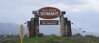
We’re there on the Memorial Day weekend, when even some of the thousands of churches in Utah are flying flags, and it seems altogether appropriate that we should be climbing towards the high point of the road, a pass called “Soldier Summit”.

Which, as it turns out, is a major real-estate development, and marked solely by a real-estate sign.

And this “Blue Star” highway is part of a patriotic movement, rather than a mere local curiosity:

The Blue Star Memorial Marker Program of the National Garden Clubs, Inc. began in 1945 to honor the men and women serving in the Armed Forces during World War II. The name was chosen for the star on flags displayed in homes and businesses denoting a family member serving. Garden clubs pictured a ribbon of living memorial plantings traversing every state. The designation of Blue Star Highways was achieved through petitions to the state legislatures and cooperation with the Departments of Transportation. A uniform marker was designed to identify the Highways. 
The Blue Star Memorial Program grew to extend thousands of miles across continental U.S., Alaska, and Hawaii. All men and women who have served, are serving, or will serve in the Armed Forces of the United States are included. 

----------


The next day, which is the last day of the Memorial Day weekend, we arrive at the KOA in Romeroville, New Mexico. They have a special on: veterans get a reduction. The lady knows we’re from Canada, but doesn’t hold that against us: am I by any chance a veteran?  
I joke, “I don’t suppose being a retired reserve naval officer in Her Majesty’s Canadian Forces counts?”

But it does, and she thanks me for my service, before showing us to our site, driving her quad with the McCain/Palin poster on the back.

---------- 


Fort Sumner, New Mexico, is an unprepossessing small town, which features a couple of gas stations and, thanks to the Pecos River, the only trees or greenery for miles.


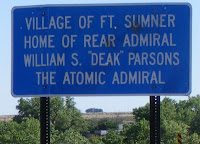
The rest stop overlooking the Pecos sports several signs, one to tell us that Billy the Kid’s grave site is located here, and one to tell us that this is the home town of “the Atomic Admiral”, William S. “Deak” Parsons.

Take that, Port McNeill, home town of Willie Mitchell!

American Corrections

Maybe American prisons just advertise better, or maybe our travels took us past a concentration of them; whatever the reason, on our trip from Vancouver to Austin we saw, or saw direction signs to, no fewer than a dozen prisons, and probably more. None of these were in Canada, although I know there's at least one major prison somewhere in the Fraser Valley.

One couldn’t avoid the impression that, for many of the communities we passed through, incarceration is an important - in some cases the most important - industry.


Imagine my delight then, to have this confirmed on line, as I was checking the name of one prison I thought I remembered passing, high in the mountains of Colorado:  

More than half the jobs in Fremont County stem from the corrections industry. Yet, despite living in close proximity to these 13 different prisons, area residents and visitors soon discover the diversity of the Royal Gorge Country is what makes it such a great place to visit, live and work.

Friday, July 3, 2009

Flags

July 1 was Canada Day. As is increasingly the custom, even here on our island off the left coast, it was marked by a good deal of flag flying.

One notices this because flying a Canadian flag is, for most of us, ceremonial, and occasional, and distinctly not everyday normal. In Canada, flags traditionally fly on government buildings, schools, and motels catering to US tourists. Most individual Canadians don’t apparently feel a need to advertise: we know we’re in Canada; we expect visitors to know that as well. And for most of us flying a flag to demonstrate patriotism would be vaguely embarrassing: we’re not, after all, like those chauvinistic Americans!

Americans, on the other hand, I discover from two recent extended van trips through the heartland, fly American flags. All the time. Especially, it appears, those living in ranching America, the Land of the Long Driveways.

These flags are clearly not flying for our benefit, so it may be impossible for a thoroughly-indoctrinated Canadian such as myself to parse them. When we visited Isaac’s parents in Minnesota a couple of years ago I asked Isaac’s dad, Irv, if he could explain flag culture as exhibited in rural Montana, but he was unable to be very helpful beyond what I had already sort of inferred: Republican voters are more likely to fly the Stars and Stripes than are Democrat voters. If that’s true, there are a lot of Republican voters in rural Montana. But we already knew that, so maybe it’s a solidarity thing. (If solidarity is not too socialistic a concept.)

In Utah, in a suburb of Salt Lake City, we saw one of those traditional Mormon churches (I wonder if the designer of the original gets a royalty for every one built, and, if he does, how wealthy he is) flying an American flag. I’m pretty sure I’ve never seen that before, not even on Canadian military bases.

Dealers of American cars in Texas fly bedsheet-sized flags. That must be an appeal to patriotism: buy American. But what does the size say? I’ve never seen larger except in Turkey, and in their case the issue is clearly a need to overcome feelings of inadequacy, like those ads for penis-enhancements. (we’re significant, we have a huge army, see our enormous flags!) Do dealers of Fords, Chevrolets and Dodges feel somewhat inadequate? Texas Toyota dealers don’t fly oversized flags (in fact, I don’t recall any flags at all) but there are lots of Toyotas in Texas.

In ranchland Texas the driveways frequently sport a Texas flag on one side and a Stars and Stripes on the other. This appears to be something of a theme in Texas generally, and I gather has something to do with the inalienable right of Texans to either secede or divide into four states, if they want to. Sort of like Quebec, except that the language in Texas is Spanish, and most Spanish-speakers in Texas just want to be Americans who speak Spanish.

After we returned to Canada just south of Regina, I was on the lookout. Canadian prairie farms don’t, as a rule, fly flags, but we did spot a driveway not far from the Battlefords with a Canadian flag on one side and a Saskatchewan flag on the other.

Must be transplanted Americans.